 » Media Center » News Releases » 2022 » February
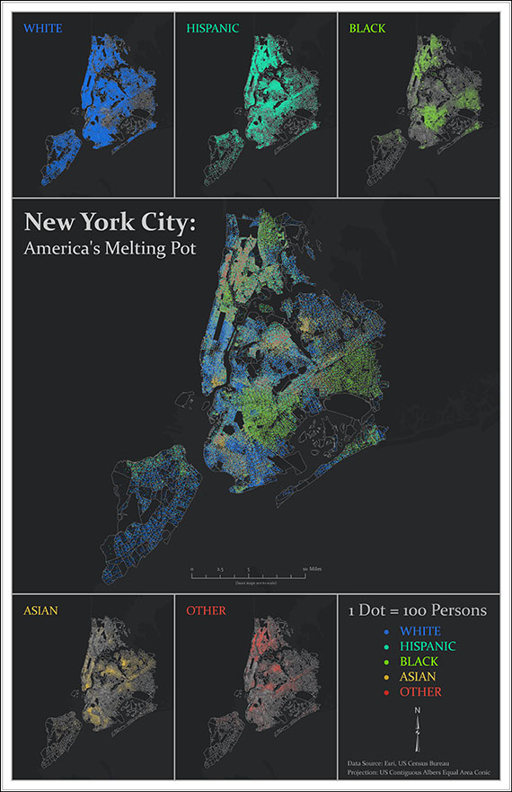
A map of racial distribution in New York City created by Northwest graduate student Tyler Morton will appear in the annual “ESRI Map Book.”
A multivariate dot density map created by a Northwest graduate student to illustrate racial distribution in New York City has earned publication in a book showcasing mapmakers from throughout the world.
Tyler Morton used U.S. Census Bureau data to create the map in Dr. Eva Wu’s cartographic design and visualization course. ESRI, a global leader in Geographic Information Science (GIS) software, will publish the map in its annual “ESRI Map Book” in July.
“This is a tremendous accomplishment for one of our graduate students and is a testament to the student’s hard work and to Dr. Wu’s support and assistance,” Dr. Dawn Gilley, the chair of the Department of Humanities and Social Sciences, said.
Morton said the publication validates his hard work as a graduate student and the decision he made to change career paths.
“Taking the leap to go into GIS while balancing work, school and life took a lot of consideration,” Morton said. “To have my map selected amongst many other submissions with authors who were much more experienced felt like confirmation that I made the right decision and that my hard work was worth it.”
Morton earned a bachelor’s degree in business administration from the University of Nebraska at Lincoln but was unsure of his career path afterward.
He worked as a sales representative at a Land services company and then transitioned into information technology where he learned about geographic data analysis. He taught himself the basics of the industry and then took a leap of faith, during the COVID-19 pandemic in 2020, and enrolled at Northwest to obtain a graduate certificate and master’s degree in GIS.
Northwest’s GIS master’s program is an online program for professionals working in conservation energy, intelligence, police, military or health industries who aspire to be at the forefront in data-gathering to uncover patterns and solve complex geo-spatial challenges.
Students expand their technical data-mapping skills using both hardware and software technology systems and discover innovative ways to capture, process, analyze and represent data in real-world settings. They advance understanding of remotely sensed information as it pertains to a GIS landscape and examine the latest trends in cartography.
Morton, who resides in Broomfield, Colorado, says the online GIS master’s program at Northwest has allowed him to balance personal and career activities with his desire to earn an advanced degree.
“The journey has been challenging yet extremely rewarding,” he said. “For the first time, I’ve managed to maintain a 4.0 GPA, which has been one of the proudest accomplishments of my life. It has made the late nights and busy weekends worth it.”


